| ZONING BY-LAWS Devens Regional Enterprise Zone November 18, 1994 |
The Joint Boards of Selectmen: Town of Ayer Town of Harvard Town of Lancaster Town of Shirley The Massachusetts Government Land Bank |
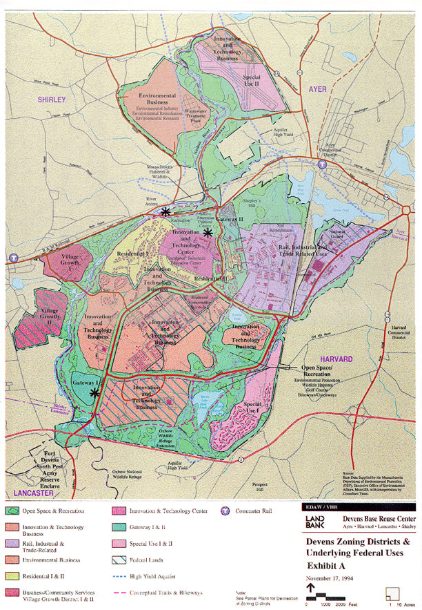
V. ZONING DISTRICTS AND ZONING MAP
The following zoning districts, as further identified on the Zoning Map, are hereby established at Devens. The description of the development goals applicable to each zoning district are listed in subparagraphs 1 through 14 of this section A. The development goals reflect the development, marketing, planning, and environmental objectives outlined for Devens in the Reuse Plan. The uses permitted in Devens are described in Article VI. The uses permitted in each zoning district are listed in the Table of Permitted Uses attached at Exhibit D. If there are any inconsistencies or conflicts between the development goals and the permitted uses listed on Exhibit D and described in Article VI, the permitted uses shall control. The Commission shall, on or about July 1, 2000, and every five (5) years thereafter, issue a written assessment of the status of the redevelopment effort, evaluating the progress, type, and character of development in each district, as well as the realistic market expectations for future development in each district, for the purposes of comparing such assessment to the Development Goals outlined below.
b. Development Goals: The primary goal of this zoning district is to locate and site industries that contribute to or capitalize on the increasing sensitivity to and awareness of environmental remediation and recycling, and the development of products emanating from these activities. Identified as environmental businesses in the Reuse Plan, these businesses and industries may range from businesses that use traditional industrial recycling processes to businesses that apply new remediation technologies or businesses that manufacture pollution abatement or remediation equipment. c. Interim Use: Agriculture may be permitted on an interim basis, as provided in Article VI E 2 of the By-Laws.
b. Development Goals: The primary goal of this zoning district is to provide for a range of educational, cultural, institutional, and office uses that will serve as a distinct entryway and point of arrival for Devens. The permitted uses in this zone will capitalize on the unique natural and locational attributes of the site and help define the vision of the Devens Regional Enterprise Zone for purposes of economic development and environmental protection, as set forth by the goals and objectives of the Reuse Plan. The Gateway I site, also known as the Jackson Gateway, possesses a particular natural beauty that is to be enhanced and preserved by potential users. Additional siting and design criteria may be established by the Commission in the Regulations to ensure the future preservation of those attributes while encouraging uses that promote the Gateway theme.
b. Development Goals: The primary goal of this zoning district is to provide for a range of cultural, educational, institutional, and open space/recreational uses that will serve as a distinct entryway and point of arrival for Devens. The permitted uses in this zone will capitalize on the unique attributes of the site and help define the vision of the Devens Regional Enterprise Zone as set forth by the goals and objectives of the Reuse Plan. By creating a compatible scale and combination of built and open environment, the Verbeck zoning district will establish the sense of arrival to the Devens Regional Enterprise Zone as well as respecting the transition from the adjacent business, residential, and open space uses in Ayer. Additional siting and design criteria may be established by the Commission in the Regulations to ensure the future development of these attributes while encouraging uses that promote the Gateway theme.
b. Development Goals: The primary goal of this zoning district is to attract business activities that will reflect the intent and spirit of the Innovation and Technology Zone without the more intrusive or larger scale industrial component. In order to ensure sensitive and responsible use of these areas, due to their proximity to adjacent land uses, the Commission will be required to consider the following use and siting criteria when reviewing development proposals:
(ii) degree of visibility from strategic viewing points in adjacent areas of Harvard; (iii) aesthetic quality of site development; (iv) buffering/screening of development; (v) site lighting designed to minimize visibility from surrounding areas; and (vi) preservation of existing vegetation, where feasible.
b. Development Goals: The primary goal of this zoning district is to allow a broad range of industrial, light industrial, office, and research and development uses. The compatibility of these uses with the possible retention of local air service at Moore Army Airfield will be encouraged. In acknowledgement of the possible retention of local aviation uses, special events shall be allowed with special regulation. Uses supporting and complimenting the adjacent Innovation and Technology and Environmental Business Zones will also be encouraged. Buffers may be required between adjacent areas in Ayer along and near Route 2A.
b. Development Goals: The primary goal of this zoning district is to foster the evolution of a residential neighborhood at Devens, intending to meet housing needs for residents of the towns in the Devens area. The reuse of the existing housing stock will be encouraged, as well as future development of additional housing types, provided that nothing contained herein shall prevent the demolition of housing stock, as needed. Additional siting, density, and design criteria may be established by the Commission in the Regulations to ensure:
(ii) sensitivity to visual impacts; and (iii) reuse of existing structures, where feasible.
b. Development Goals: The primary goal of this zoning district is to develop housing to serve the residential needs of Devens. This district will also allow office space for professional office and service uses that will be accessory to the primary residential use or a home occupation. The reuse of the existing housing stock and construction of new infill housing for residential and accessory office space will be encouraged in a manner that compliments the historic Vicksburg Square. Development of a diverse and stable residential core, as well as small scale professional office and service space, are considered compatible and vital components of the Reuse Plan and every effort will be made to ensure a sensitive and appropriate blend of these uses. Additional siting, density, and design criteria may be established by the Commission in the Regulations to address the following concerns:
(ii) visual impacts; (iii) reuse of existing structures, including historic structures, where feasible; (iv) "number of employees" and other restrictions for professional office and service uses; and (v) parking needs evaluation and requirements.
b. Development Goals: The primary goal of this zoning district is to provide a mix of small scale commercial, retail, and service uses. Uses in this zone are expected to complement and support the businesses in Devens and the needs of persons working in Devens.
b. Development Goals: The primary goal of this district is to provide commercial and senior residential opportunities for Shirley Village, while at the same time respecting the scale of the existing businesses and abutting neighborhoods. The intent is to accommodate a municipal facilities center, a variety of retail, service, and office uses of small to medium size and residential uses such as senior housing and assisted living. The Commission shall be required in its Regulations to establish design concepts which further the goal of creating a commercial center which respects village scale and layout. Said site design standards shall address issues of setback, location of parking, orientation of buildings to roadways, landscaping, site access and circulation, general compatibility of building massing with the existing village, and related considerations, including a maximum square footage use by a single business of fifty thousand (50,000) square feet. At the same time, it is intended that design options remain flexible, so as to encourage high quality and creativity in site and building design. Additional siting and design criteria shall be established by the Commission in the Regulations to address issues relating to:
(ii) visual compatibility with the Shirley Village environment; (iii) height restrictions; and (iv) options for clustering of buildings and flexible design that enhances connections to the existing Shirley Village.
b. Development Goals: The primary goal of this zoning district is to provide space to those industries and businesses that develop and require additional space within Devens or that relocate to Devens. Permitted uses in this zone exhibiting one or more of the following qualities will be encouraged:
(ii) expansion of a business; (iii) educational/academic links; (iv) research and development orientation; and (v) business connections or support services to other industries on Devens.
c. Interim Use: Agriculture may be permitted on an interim basis, as provided in Article VI E 2 of the By-Laws.
b. Development Goals: The primary goal of this zoning district is to provide an area for small scale development involving office, light industrial, research and development, and compatible outdoor recreational, cultural, conference, institutional, and municipal types of uses, in a manner that is harmonious and in scale with abutting areas of Shirley Village. Additional siting requirements may be established by the Commission in order to be responsive and sensitive to adjacent uses. Any such additional requirements shall consider the following:
(ii) site specific design requirements; (iii) industrial performance standards; and (iv) retention of existing active recreation uses within the district.
b. Development Goals: The primary goal of this zoning district is to provide a development area that will generally be available to businesses that utilize or rely in whole or in part upon rail lines, surrounding rail-related uses, multi-modal transportation links, or trade with national or international emerging markets. Other uses in the district that generally support and enhance the transportation and trade-related uses will be encouraged. Additional siting requirements may be established by the Commission in the Regulations to protect the environment, particularly the aquifer.
b. Development Goals: The primary goal of this zoning district is to provide an urban center for the Devens Regional Enterprise Zone in which incubator ventures and a broad range of businesses are encouraged. Its combination of historic buildings and traditional open space provides an environment unique to the former base and allows for an intensity of both business and public uses that is singular to Devens. Development of design, siting, and retrofitting criteria should be flexible in order to accommodate a wide range of users and their special needs, and any ancillary support services. A major theme for this zone is to encourage and promote the development of academic and educational support links for the entire Devens Regional Enterprise Zone, as set forth in the Reuse Plan.
b. Development Goals: The Open Space and Recreation zoning district is considered a primary and essential component of the Reuse Plan. The goal of this zoning district is to preserve and enhance the natural beauty and sensitive natural resources of Devens and serve as a buffer and transition zone for other uses. In addition, uses are expected to serve a wide range of passive and active recreational needs of the Devens Regional Enterprise Zone and the region as a whole. c. Prohibited Uses Limited to This District Large-scale facilities for open air concerts are prohibited in this district. d. Interim Use: Agriculture may be permitted on an interim basis, as provided in Article VI E 2 of the By-Laws.
|
| By-Laws Table of Contents Home Search Next Section
|